BJ and Black launches are currently closed to vehicle access behind Sierra Pacific gates. Hike-in access is allowed. Thank you for your patience while we work with Sierra Pacific to get new liability waivers. Any changes to site access will be communicated to club members.
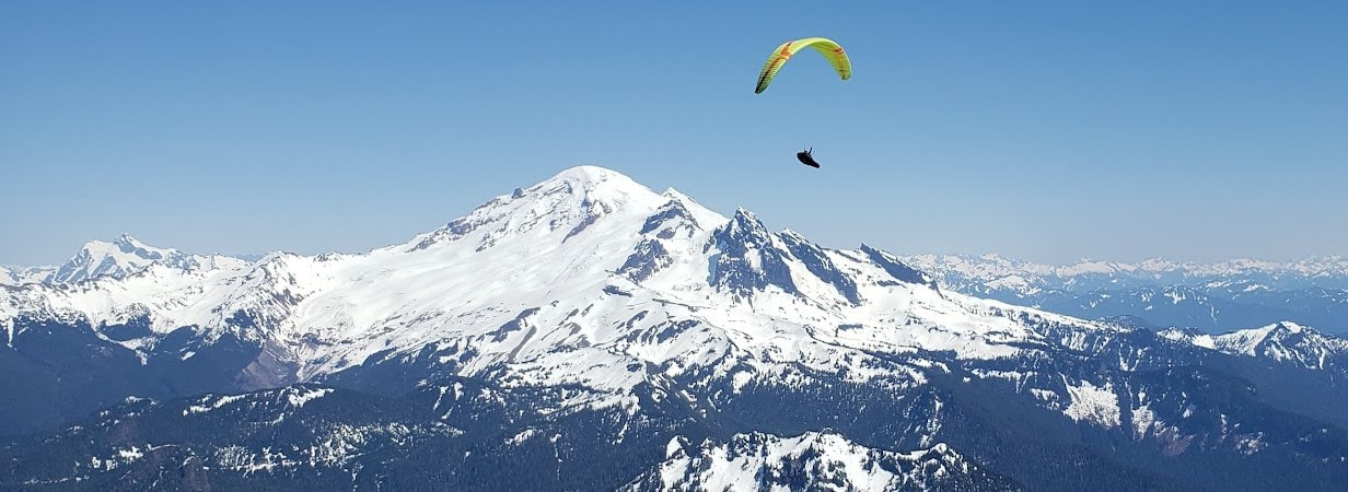
Photo Credit: Jesse Williams
Revision Date: 2/25/2024
Big Johnson Site Guide
The Big Johnson flying site (also referred to as Racehorse Ridge and BJ) is located about 18 miles east of Bellingham, WA. Access is via a locked gate; many north-end pilots have keys and visiting pilots are welcome. Landowners require USHPA membership. The site is administered by the North Cascades Soaring Club.
The BJ launch site does not have any areas that are suitable for basic training. The launch site can be used for rated pilots accomplishing solo flight under the supervision of a USHPA Instructor, and for Tandem instructional flights conducted by USHPA Tandem Instructors with USHPA Student-rated (or above) pilots.
Site Contact: Roger Brock, 360-319-3881
BJ South Launch Elevation: 1,800'
- GPS Coordinates: 48º51'38.55"N 122º7'32.83"W
BJ North Launch Elevation: 2,260’
- GPS Coordinates: 48°51'50.53"N -122°7'14.14”W
Main Paragliding Landing Zone Elevation: 350'
- GPS Coordinates: 48º51'36.41"N 122º8'42.47"W
Main Hang Glider Landing Zone Elevation: 320’
- GPS Coordinates:48°50'57.58"N, 122° 9'21.34"W
Flight Types:
Mountain/Thermal and Ridge Lift
Best Season to Fly:
Allowed usage year-round, the best time to fly is typically in the Summer and Fall.
Best Time to Fly:
Noon to Sunset. Spring and Summer may produce strong midday thermals. Caution should be taken launching midday. Evenings typically offer smoother thermals.
Protocols:
The BJ launch may be closed during the dry season due to high fire danger, and during the winter due to snow. All pilots must get a site orientation before flying.
Potential Hazards:
The primary risks associated with this site include the LZ which is surrounded by trees and power lines. If wind is strong in the valley, the LZ can have rotor and turbulence associated risks. Thermals at this site can be strong midday, it is recommended that pilots gain their P3/H3 rating prior to flying in strong midday conditions at this site. Evenings are often smoother with ridge lift and light thermals. These evening conditions can be appropriate for P2/H2 pilots with supervision.
Ratings:
Intermediate/P-3/H-3 (or Novice/H-2/P-2 when mellow)
P-3/H-3 requirements: The pilot has the knowledge and skills to fly most sites in mild to moderate soaring conditions, and to judge when the site and conditions are within the pilot's skill, knowledge, and experience level. The pilot understands the USHPA paragliding/hang gliding rating system and recommended operating limitations, and the FARs and other flying rules applicable to their flying (ridge rules, thermal right of way, FAR 103, aircraft sectional use and regulated airspace avoidance, etc.). The pilot shall use good judgment and have a level of maturity commensurate with the rating.
P-2/H-2 requirements: A Novice paraglider/hang glider pilot has the knowledge and basic skills necessary to fly and practice without direct instructor supervision but within significant operating limitations. The pilot understands the USHPA paragliding/hang gliding rating systems and recommended operating limitations. The pilot shall use good judgment and have a level of maturity commensurate with the rating.
Launches:
The BJ launches are dirt/ grass natural slope launches. The launching zones are small and characteristic of mountain launch sites. Paraglider pilots launching BJ should have excellent kiting skills and experience with technical launch sites. There are no obstructions on the launches; however, the close proximity to trees and the short, steep runways require advanced launching techniques. These launches are mainly used for paragliding; minimal hang glider set up area is available.
Note: The old Hang Glider launch (Upper Launch) has not been used for several years due to the access road being overgrown. This launch is now closed. The upper launch at BJ is also closed.
BJ South Launch:
Recommended Wind Strength:
- PG - min 0, ideal 10, max 15, gust 2
- HG - min 0, ideal 15, max 20, gust 5
- Ideal - 180° to 230°
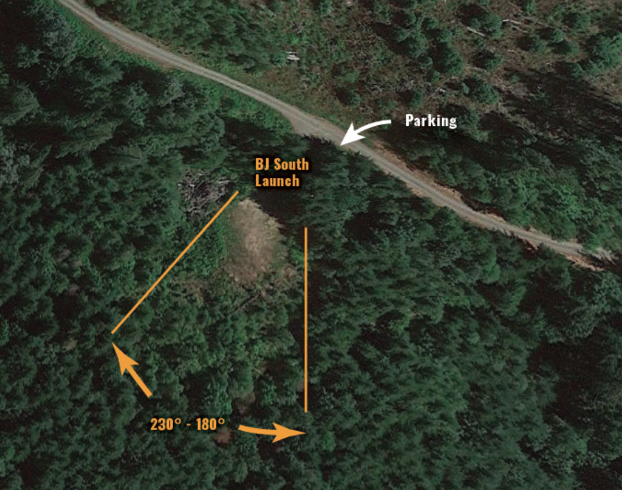
BJ South launch
BJ North Launch:
The BJ North Launch is shallower in slope and is generally unsuitable for hang glider use. There are several cut-off stumps, rocks, and other tripping hazards that may be present in the launching runway. The launching surface is mostly gravel and dirt. Small sticks and roots are presented in the setup and launching areas and can easily become tangled in lines. Care should be taken to ensure lines are fully cleared before committing to takeoff. Several lone-standing tall trees are present immediately below launch. Pilots need to be aware of these trees and actively steer clear.
Recommended Wind Strength:
- PG - min 0, ideal 10, max 15, gust 5
- Ideal - 35° to 300°
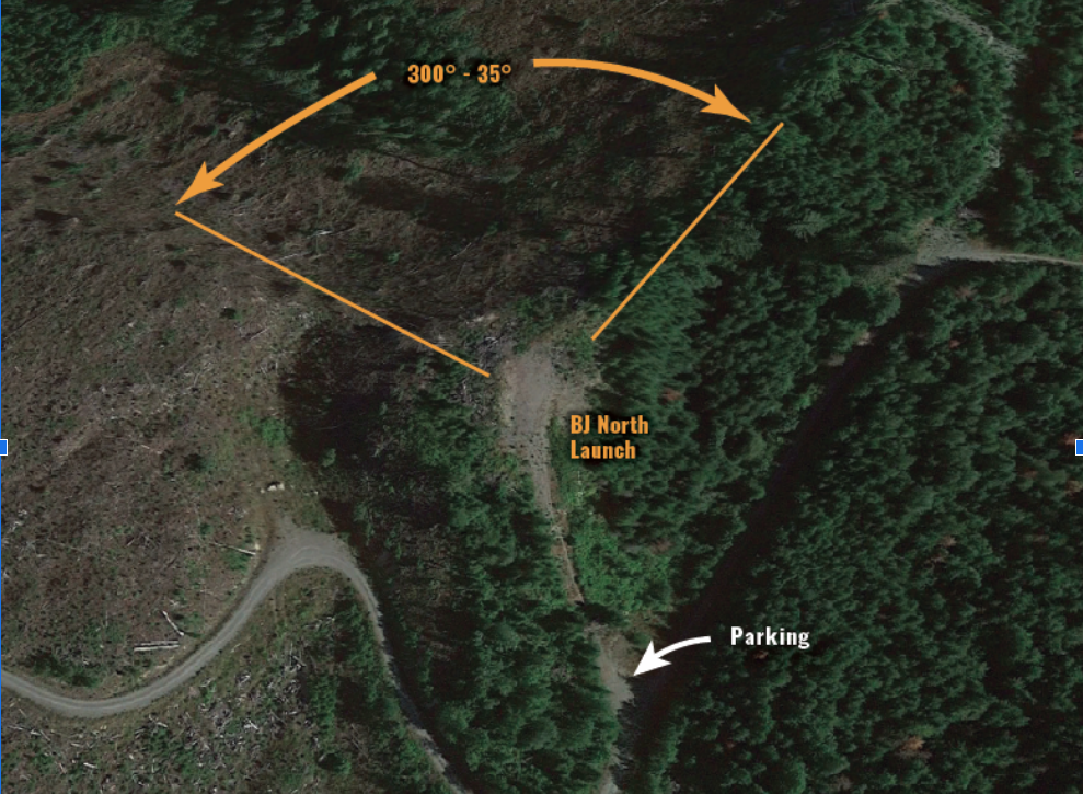
BJ North Launch
Paraglider Landing Zone:
The main paraglider LZ is PRIVATE PROPERTY, but the owner has given permission to land there. The LZ is located on the North Fork road. There are trees and power lines surrounding LZ in addition to a row of trees partially bisecting the LZ. Appropriate approach patterns are communicated to new/visiting pilots during site orientation.
Note: This LZ can become extremely thermic during mid-day summer conditions. Strong valley winds can also create rotor and associated turbulence. The LZ can not be seen from either BJ launches.
The required glide ratio to reach the main paragliding LZ is approximately 2.2 and 2.7 from BJ South Launch and BJ North Launch, respectively.
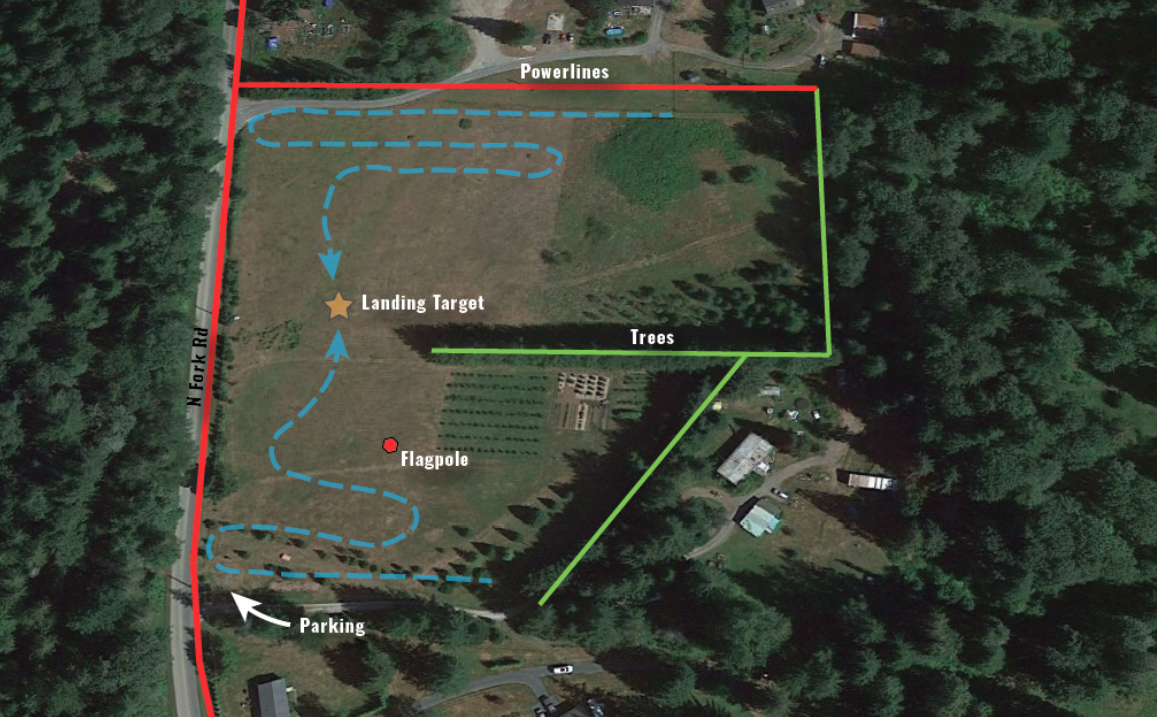
BJ Paraglider Landing Zone

Google map view of South launch and Paraglider LZ
The main hang gliding LZ is PRIVATE PROPERTY, but the owner has given permission to land there. The LZ is located along Mount Baker Highway and across from the North Fork Nooksack River. The LZ is a grassy field surrounded by tall trees and power lines along the highway. Cattle, elk and other wildlife may be present in the LZ.
Notes: Beware of switching winds. LZ is to the west of launch west side of the river along the Mt Baker Highway.
Notes: Beware of switching winds. LZ is to the west of launch west side of the river along the Mt Baker Highway.
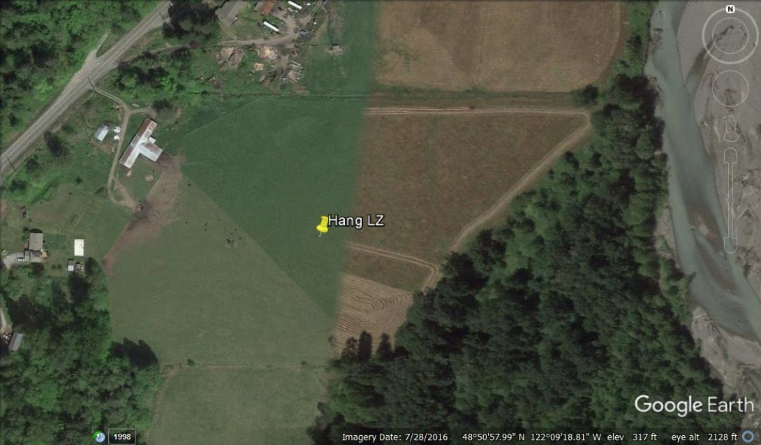
Hang Glider Landing Zone
Directions:
From Bellingham, take Exit #255 off I-5 for WA-542 E/Sunset Drive toward Mt Baker. Follow WA-542 for approximately 18 miles. Turn right onto Mosquito Lake Rd (at Welcome Grocery Store) then turn left onto N Fork Rd. Follow N Fork Rd approximately 1.5 miles to the paraglider LZ.
Access:
Gravel, 4WD. BJ South launch is accessed via a locked gate. Current NCSC and USHPA members with a P3 rating and above may get a gate key from the NCSC.
Incidents:
Should be documented by emailing the club: [email protected] attention to Safety officer. In an emergency, Call 9-1-1 first.
BJ Site Use Rules:
- Key members must be a minimum of H3 or P3 and NCSC members.
- Key members are responsible for making sure that all guest pilots are current USHPA members with a minimum H2 or P2 pilot rating, giving a site orientation, and adequate knowledge of the flying site.
- Key members must have guests sign the “Sierra hold harmless agreement” and return before access.
- Key members must escort their guests onto Sierra Pacific property and assume responsibility for their guest's safety, actions, and orientation to the site and these rules while on Sierra Pacific property.
- Keys are not transferable and are not to be loaned or duplicated.
- All pilots and tandem passengers must be current USHPA members or have a signed 30-day membership/waiver.
- Communications with landowners of said property shall be done through the club via the designated site coordinator. Please do not hesitate to contact us at our dedicated email address for any inquiry regarding the site coordinator.
- Appropriate vehicle speed on all roads leading to flying sites including those within surrounding communities. (Excessive speeds are the primary cause of most site closures)
- Drivers shall make every effort to minimize vehicle impact upon roads. Leave no evidence of our passage on such roads.
- No use of gas combustion-powered tools during fire season.
- No commercial activities are allowed.
- No Smoking.
- No Fires, No tree cutting, camping, wood gathering, or any other activities unrelated to flying.
- Be respectful and courteous to everyone we encounter while representing our club and sport.
- Pilots shall obey local flying rules and make every effort to mitigate risk.
Several landowners don't want us landing on their property. Please familiarize yourself with these areas using the Google Earth project below. If you have any issues with landowners, please notify the club so we can update the map.
CLICK HERE to access "No landing zones"
CLICK HERE to access "No landing zones"
Join our Telegram Group: https://t.me/+sZdwU4_wR3Y5Mjlh
For further info contact:
[email protected]
[email protected]