Photo Credit: Jeff Hart
Revision Date: 2/25/2024
Blanchard Site Guide
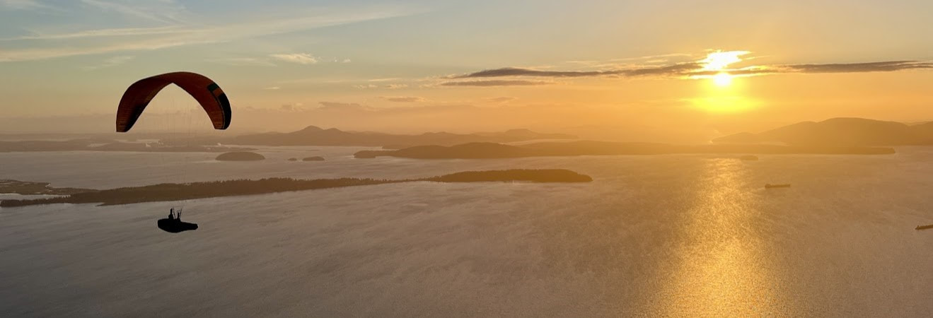
Blanchard, located at the North end of the Skagit Valley, is an excellent site for pilots. Overlooking Samish Bay, the view from the West launch includes the San Juan and Gulf Islands. Moving to the South launch two hundred feet away, completes the panorama from the blue waters of the San Juan Islands to the ever-changing patchwork quilt of farmland tucking in the Northern Skagit Valley. It's a great area to explore in the unlikely event you are unable to launch. There may not be a more relaxing place to fly. Because of its easy access and short 20-minute turn around, Blanchard is good, even if only for sledders. With a driver you can do sled rides all day, so it's a good place for newer pilots to practice launches and landings. Flying towards San Juan Islands.
Site Contact: Roger Brock, 360-319-3881
Launch Elevation: 1,252'
- GPS Coordinates: 48º36'34"N 122º25'34"W
Landing Zone Elevation: 10'
- GPS Coordinates: 48º35'34"N 122º25'15"W
Protocols:
USHPA-insured site, USHPA membership required.
Ratings:
Minimum H2, P2, M2
Blanchard Site Guide
Blanchard, located at the North end of the Skagit Valley, is an excellent site for pilots. Overlooking Samish Bay, the view from the West launch includes the San Juan and Gulf Islands. Moving to the South launch two hundred feet away, completes the panorama from the blue waters of the San Juan Islands to the ever-changing patchwork quilt of farmland tucking in the Northern Skagit Valley. It's a great area to explore in the unlikely event you are unable to launch. There may not be a more relaxing place to fly. Because of its easy access and short 20-minute turn around, Blanchard is good, even if only for sledders. With a driver you can do sled rides all day, so it's a good place for newer pilots to practice launches and landings. Flying towards San Juan Islands.
Site Contact: Roger Brock, 360-319-3881
Launch Elevation: 1,252'
- GPS Coordinates: 48º36'34"N 122º25'34"W
Landing Zone Elevation: 10'
- GPS Coordinates: 48º35'34"N 122º25'15"W
Protocols:
USHPA-insured site, USHPA membership required.
Ratings:
Minimum H2, P2, M2
|
Flight Types:
Thermal and Ridge-Lift Best Season To Fly: Allowed usage year-round, the best time to fly is typically in the Spring and Fall. Best Time to Fly: Noon to Sunset |
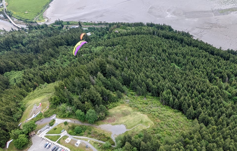
South (left) and West (right) launches from the air.
|
Launches:
Both the West-facing and South-facing launches are accessed from the Samish Overlook and are within walking distance of each other. The launches are moderately-sloped ramps with gravel and grass cover. Both launches are relatively unobstructed; Pilots should visibly make sure all clearances are adhered to before launching.
West Launch:
The West Launch is suitable for several gliders to lay out side-by-side or slightly staggered at once, with one to two pilots launching in the window at a time. The launching zone can get crowded, pilots should use common courtesy and setup/check equipment in non-active launching zones.
Note: wind conditions should be determined before launching. North to Northwest wind can create a significant rotor from the north-facing tree line that can affect the launching zone and create hazardous launching conditions.
Recommended Wind Strength:
South Launch:
The South Launch is suitable for several gliders to lay out side-by-side at once, with two pilots launching in the window at a time. The launching zone can get crowded, pilots should use common courtesy and setup/check equipment in non-active launching zones, typically behind the launching zone or to the east along the entrance path.
Note: wind conditions should be determined before launching. East wind can create a significant rotor from the south-facing treeline that can affect the launching zone and create hazardous launching conditions.
Both the West-facing and South-facing launches are accessed from the Samish Overlook and are within walking distance of each other. The launches are moderately-sloped ramps with gravel and grass cover. Both launches are relatively unobstructed; Pilots should visibly make sure all clearances are adhered to before launching.
West Launch:
The West Launch is suitable for several gliders to lay out side-by-side or slightly staggered at once, with one to two pilots launching in the window at a time. The launching zone can get crowded, pilots should use common courtesy and setup/check equipment in non-active launching zones.
Note: wind conditions should be determined before launching. North to Northwest wind can create a significant rotor from the north-facing tree line that can affect the launching zone and create hazardous launching conditions.
Recommended Wind Strength:
- PG - min 0, ideal 13, max 18, gust 5
- Mini-wing - min 0, ideal 13, max, 20, gust 5
- HG - min 0, ideal 15, max 25, gust 5
- Ideal - 240° to 300°
- OK - 200° to 310°
South Launch:
The South Launch is suitable for several gliders to lay out side-by-side at once, with two pilots launching in the window at a time. The launching zone can get crowded, pilots should use common courtesy and setup/check equipment in non-active launching zones, typically behind the launching zone or to the east along the entrance path.
Note: wind conditions should be determined before launching. East wind can create a significant rotor from the south-facing treeline that can affect the launching zone and create hazardous launching conditions.
Recommended Wind Strength:
- PG - min 0, ideal 13, max 15, gust 5
- HG - min 0, ideal 15, max 25, gust 5
- Ideal - 170° to 230°
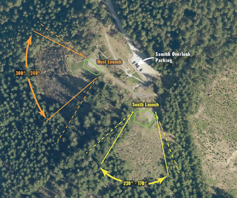
Ideal Wind Directions
|
Landing Zone:
The main LZ is PRIVATE PROPERTY, but the owner has given permission to land there, EXCEPT when the hay is tall and ready to cut. Please be sensitive to the concerns of this property owner, which means: don't block the driveway, stay away from the house (no fly-overs), Don’t Potty in the ditch, don't block the road, and don't bother the neighbors. Keep the number of parked cars to a minimum. There is additional parking along the road near the organic garden a quarter of a mile --at the first intersection--to the south. If you were to upset this very gracious property owner, you would also incur the wrath of many pilots. Obstructions: high grass, deep puddles in the rainy season – best landing approach is on the E-W-facing road in the center of the LZ. Notes: 5 to 1 L/D to LZ. BEWARE: Some pilots have failed to reach LZ in strong conditions. There are numerous crisscrossing power lines in the LZ vicinity (see map below). |
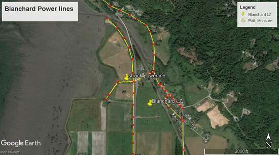
Power lines around Landing Zone
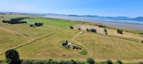
Landing Zone (View Pointing SW)
|
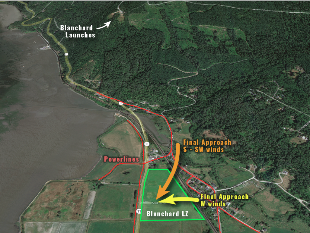
Landing Approach

Parking Protocol
Directions:
Access: Gravel, 2WD, DNR discover pass required for parking at Samish Overlook.
Google Maps: Landing Zone
Google Maps: Samish Overlook
From Seattle:
Take Alger Exit #240 off I-5. Head west on Samish Lake Road for approx. 1/2 mile. Take your first hard left (more than 90 degrees) onto Barrel Springs Road. Approximately 6/10 of a mile, turn right on Blanchard Hill Road. It's a dirt road marked by a large clear cut. On the gravel road you will pass by trail-head parking for Lizard and Lily Lakes. After approx. 1.6 miles, turn left on gravel road (T intersection). There is an bright Yellow looking barrel gate, swung back on this road. Go approx. 2.2 more miles to the end of the road.
From LZ (about 20 minutes):
Go south from LZ on Chuckanut, take your first left Colony Rd. Go to stop sign at two carved bears on a stump. Turn right onto Colony Road. Stay on Colony for a few miles until you come to Wood Road (a T intersection across from a blue barn with a white corral fence). Turn left onto Wood Road and go to first intersection. Bearing right onto Barrel Springs Road, continue on to Blanchard Hill Road, a DNR maintained gravel road. Follow the directions to launch.
Incidents: should be documented by emailing the club: [email protected] attention to Safety Officer. In an emergency, Call 9-1-1 first.
Blanchard Site Rules:
- USHPA membership is required.
- No commercial activity is allowed.
- All pilots must fly with a helmet and reserve parachute.
- H2/P2/M2 rating is required unless under a certified instructor's supervision.
- Pilots must verify that all spectators are clear before launching.
- Do not top land when spectators are present.
- Drive courteously. Slow down around hikers, horses, and other drivers.
- Be good Stewards of Blanchard Mountain. Do not cut trees.
- Please be respectful of other site users.
Several landowners don't want us landing on their property. Please familiarize yourself with these areas using the Google Earth project below. If you have any issues with landowners, please notify the club so we can update the map.
CLICK HERE to access "No Landing Zones"
Join our Telegram Group: https://t.me/+sZdwU4_wR3Y5Mjlh
Contact NCSC for further info:
[email protected]
CLICK HERE to access "No Landing Zones"
Join our Telegram Group: https://t.me/+sZdwU4_wR3Y5Mjlh
Contact NCSC for further info:
[email protected]